 Erosion Operator
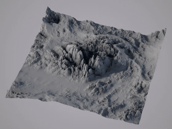
In earth science, erosion is the action of surface processes (such as water flow or wind) that removes soil, rock, or dissolved material from one location on the Earth's crust, and then transports it to another location (Wikipedia).
The Erosion Operator simulates this phenomenon.
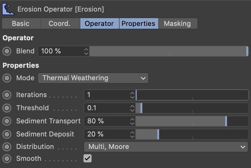
Thermal Weathering / Abrasion
Abrasion is a process of erosion which occurs when material being transported wears away at a surface over time. It is the process of friction caused by scuffing, scratching, wearing down, marring, and rubbing away of materials (Wikipedia).
In Terraform4D, thermal erosion / abrasion simulates the transport of sediment downhill (from higher to lower places on the terrain). Over time, mountain tops will shrink and become less edgy, while sediment fills up smaller valleys and deposit below slopes.
Note that this is an actual simulation, and not a fake, so prepare for soa short waiting time when employing erosion. It is a simplified simulation that does not take water flow into account.
Iterations
The erosion simulation is run multiple times on the terrain. Each run will erode the terrain a little more.
This parameter is the most important one, regarding erosion strength and calculation time. Larger values will erode more and take longer to calculate.
Threshold
Sediment will only be transported from a higher to a lower point on the terrain if the slope is steep enough. This value defines how steep it has to be for erosion to kick in.
Smaller values will erode the terrain more equally, while larger values will erode steeper slopes more.
Sediment Abrasion
This defines the amount of sediment that is transported downhill. Larger values will shrink mountain tops more.
Sediment Deposit
Some of the sediment disappears while being transported (e.g. due to wind), the remaining sediment is deposited on the lower ground. This parameter controls how much of the sediment disappears.
While a value of 100% keeps all sediment and results in very soft results. A value of 0% deposits none of the sediment, making mountains a lot thinner and filling no valleys.
Distribution
This parameter controls how the simulation looks up neighbor points for the points it erodes.
- Multi, Neumann
Sediment is taken from a higher point and and distributed to the lower neighbor points North, East, South, or West. - Multi, Moore
Sediment is taken from a higher point and distributed to the lower neighbor points North, Northeast, East, Southeast, South, Southwest, West, or Northwest.
It calculates a bit slower than the Neumann neighborhood, but produces prettier results. - Single, Neumann
Sediment is taken from a higher point and deposited at the lowest neighbor point North, East, South, or West.
It calculates quite fast, but looks less appealing than the Moore neighborhood. However, for stylized landscapes, it might actually do a good job. - Single, Moore
Sediment is taken from a higher point and deposited at the lowest neighbor point North, Northeast, East, Southeast, South, Southwest, West, or Northwest.
It calculates a bit slower than the Neumann neighborhood, but produces prettier results.
Smooth
If this is enabled, a filter will be applied to the heightfield after each erosion iteration. This avoids artifacts due to extreme parameters settings at the cost of detail.
Coastal
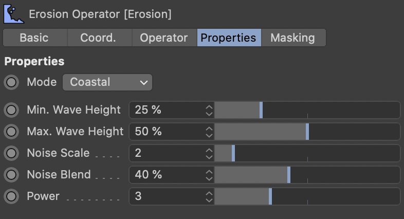
Coastal erosion occurs where waves of water break on solid ground. The ground is slowly washed away in a characteristic way. Since waves are of a random height, the effect gets exponentially stronger closer to the water surface.
This effect is simulated here. It's not an actual simulation, but rather a statistical approach. Therefore, it's the fastest of the erosion modes. Additionally, it does not take any sediment deposit into account.
It's generally suitable for creating coastal cliffs (think of south England) and beachy areas.
Min. Wave Height
Everything below this value will experience maximal erosion. Above this value, erosion strength will decrease until the Max. Wave Height.
0% correlates to the lowest point, 100% to the highest point of the terrain.
Max. Wave Height
Above this value, the terrain won't experience any erosion.
0% correlates to the lowest point, 100% to the highest point of the terrain.
Noise Scale
A simple noise is used to apply local variation to the erosion effect. Scale the noise with this value.
Noise Blend
The intensity of the noise variation.
Power
This is basically the main strength of the coastal erosion. Lower values create a more subtle effect, larger values result in a more intense look.
Power
If you don't like the hard edge that occurs at the upper end of the eroded terrain, increase this value.